Linn Cove Viaduct History
Linn Cove Viaduct History
After 52 years of construction, the Blue Ridge Parkway was completed in September 1987.Ground was broken on September 11, 1935 at Cumberland Knob, North Carolina, and all but 7.5 miles of its 469 were constructed by 1967. During the intervening twenty years, this final section-which skirts the rugged and rocky perimeter of Grandfather Mountain in North Carolina-presented state and federal officials with a number of obstacles that were solved with perseverance and innovation.
Establishing the Route
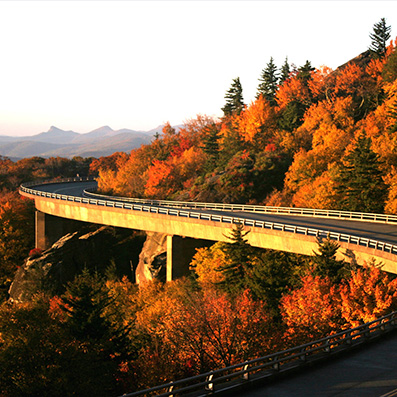
The exact route location of this segment, commonly referred to as the “missing link,” created a lengthy and heated controversy between private individuals and the National Park Service. Finally, North Carolina Governor Dan K. Moore negotiated a compromise location. A key factor in this controversy was environmental concern. Engineers were faced with a serious question: How to build a road at an elevation of 4,100 feet without damaging one of the world’s oldest mountains? National Park Service landscape architects and Federal Highway Administration engineers agreed the road should be elevated or bridged, where possible to eliminate massive cuts and fills. Figg and Muller Engineers, Inc. developed the bridge design and construction method. The result: the Linn Cove Viaduct at milepost 304.6, the most complicated concrete bridge ever built, snaking around boulder strewn Linn Cove in a sweeping “S” curve.
Building the Viaduct
Construction was delayed until 1979, when Congress finally approved funding. Completed in 1983 at a cost of almost $10 million, the Linn Cove Viaduct is 1,243 feet long and contains 153 segments weighing 50 tons each. Only one segment, the southernmost is straight. In order to prevent environmental damage and to allow construction to continue during severe winter weather, builders pre-cast sections indoors a few miles from the site using a process known as “match casting.” Each new segment was cast against the segment preceding it. Computer control kept measurements accurate to 0.0001 feet. Tinted with iron oxide, the concrete blends in with the existing rock outcroppings. The Viaduct was constructed from the top down to minimize disturbance to the natural environment. This method eliminated the need for a “pioneer road” and heavy equipment on the ground. The only construction that occurred at ground level was the drilling of foundations for the seven permanent piers on which the Viaduct rests. Exposed rock was covered to prevent staining from concrete epoxy, or grout. The only trees cut were those directly beneath the superstructure. The Viaduct itself was the only access road for construction. Each pre-cast section was lowered by a stiff-leg crane and epoxied into position against the preceding segment. Steel cables threaded through the segments secured the entire bridge deck. The portions of the “missing link,” most of the north of the Viaduct, were completed bit by bit between 1968 and 1987. In addition to 12 bridges, the 7.5 mile section includes a dozen parking overlooks and the 13.5 mile Tanawha Trail, stretching from Beacon Heights to Julian Price Park. A visitor center is located at the south end of the Viaduct. Here an (handicap) accessible trail leads to a beautiful view of the Viaduct from underneath, and gives hikers access to the Tanawha Trail.
Fulfilling a Dream
A ribbon-cutting ceremony on September 11, 1987 heralded the completion of the Parkway and the end, too, of a narrow and crooked 14-mile detour around Grandfather Mountain via the Yonahlossee Trail (U.S. 221). The final section is not only a triumph of engineering and sensitivity to the environment, it is a joy drive, safe but thrilling. Hugging the contours of Grandfather Mountain, the road gently curves and rolls, presenting motorists with magnificent views as it sweeps toward the sky.